Ruling it was “an extreme gerrymander,” a state judge today struck down the Maryland legislature’s redistricting of Maryland’s congressional seats, and ordered state legislators to produce a new Congressional map by the end of this month.
In the ruling, Judge Lynne Battaglia found that the eight strangely-shaped congressional districts drawn by the Democrat-dominated state legislature lack compactness and disregard existing political boundaries, like the borders of counties and cities. The map “subordinates constitutional criteria to political considerations,” the judge ruled, and thus violates the state constitution’s equal-protection and free-elections clauses. It’s the first time a Maryland state judge has struck down a redistricting map as being gerrymandered, even though the state’s districts have long been slanted in favor of Democrats.
As Eric Boehm notes,
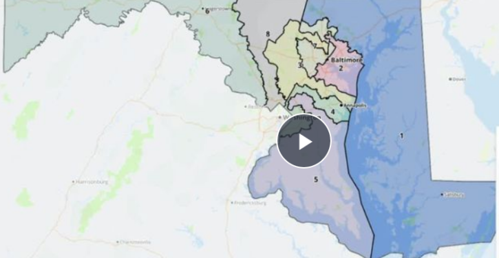
The congressional map used in Maryland for the past 10 years was one of the most highly gerrymandered in the country—even though Republican gerrymanders in places like North Carolina, Pennsylvania, and Wisconsin attracted more attention to the problem of politically motivated mapmaking. That’s part of the reason why Maryland’s congressional delegation has been split 7–1 in favor of Democrats for the past decade.
This time around, Democrats in Annapolis drew an even more gerrymandered map that would have given them an electoral edge in all eight of the state’s districts by carving up Maryland’s deep blue Baltimore/Washington corridor so that nearly all of the state’s congressional districts include some part of it. The new map received a grade of “F“ from the Princeton Gerrymandering Project, which grades congressional maps on partisan fairness, geographical compactness, and other factors.
Maryland’s Republican Governor, Larry Hogan, called today’s ruling “a monumental victory for every Marylander who cares about protecting our democracy, bringing fairness to our elections, and putting the people back in charge.”
Governor Hogan urged Maryland’s legislature to comply with Judge Battaglia’s ruling by adopting a map already drawn months earlier by the Maryland Citizens Redistricting Commission, a group that included three Republicans, three Democrats, and three politically unaffiliated residents of the state. It had produced a fair map that Maryland’s Democratic legislature had rejected.
As Boehm notes, that Commission’s “districts make geographic sense, and the parts of Maryland with more Republicans (the Eastern Shore and the western panhandle) are placed in districts more likely to reflect their local politics.” Reflecting the fairness of the Commission’s map, the Princeton Gerrymandering Project has given it an “A” grade.
The map drawn by Maryland’s Democratic legislature was less compact than the map drawn by North Carolina’s Republican legislature, which the Democrat-controlled North Carolina Supreme Court struck down as an unconstitutional gerrymander in February. The North Carolina congressional districts were not strangely shaped, usually respected existing political boundaries, and looked like this: