This post in the centenary series is about two map views of the world and the politics of the people who inhabit it.*
The maps are the stars here. For those who want to do additional reading, if you are not already familiar with Mackinder and Spykman, there are links and recommended works incorporated in the text.
(I am omitting broader reference to Alfred Thayer Mahan, the “father of modern sea power,” not because he is unimportant but because, through American preeminence and the march of technology, he effectively ruled the century from 1917 to 2017. Moreover, it is hard to see how he will not continue to do so, given that technology shows no prospect of moving us backward in our perceptions of national need and advantage. Today, we are all Mahanians. The seas are highways now, more than they are barriers; that proposition requires no demonstration anymore. Air space has some of the same quality; outer space may develop it soon, in its own way. But the insights of Mackinder and Spykman still provoke argument and have an especially illuminating relevance for modern geopolitics.)
Mackinder and Spykman
Understand at the outset: Mackinder and Spykman are a set in this treatment. They are associated with one of the “geographies.” The other I will introduce after them. Westerners, where they have addressed it, have largely viewed the second geography through the lens of the Mackinder-Spykman perspective. But I believe that’s an error. I’ll summarize why at the end.
The first glimpse of Halford Mackinder’s vision – that of an Englishman at the height of the UK’s global reach and power – came in 1904, in an article in the Geographical Journal called “The Geographical Pivot of History.” This was an early treatment, but it propounded the area of Eastern Europe and Russia (mostly Western Russia) as the “Pivot” of geopolitical history, which remained the basis of Mackinder’s theory.
His more famous work was a monograph published in 1919, just after the end of World War I, entitled Democratic Ideals and Reality. (UCLA has a digitized copy of the entire work – text only – available here.) The monograph was an attempt to frame the conditions in which reconstruction would take place after the war, and it is often paired with John Maynard Keynes’ The Economic Consequences of the Peace, also published in 1919.
Mackinder’s 1919 work is the one he is best known for among today’s students of geopolitics. In it, he fully developed his idea of the Europe-Asia seam as the Pivot Area. The area immediately surrounding it he called the “Inner Crescent,” as depicted on the first map.

At the time Mackinder wrote, a huge swath of the Inner Crescent had just been through turmoil unlike any it had seen in centuries, with three of its empires (German, Austro-Hungarian, and Ottoman) lying in ruins, having been destroyed irrecoverably by the war, and a drumbeat of unrest starting across South Asia – one that would not be quieted until decades later. In the Pivot Area – the central, defensible, resource-deep area ringed by the Inner Crescent – something alarming that no one quite understood was emerging from the rubble of the old Russian Empire.
The geography and the politics of this Inner Crescent looked much more fragile and vulnerable than they do to our eyes today. This was the perspective with which Western thinkers began the century of 1917. A hundred years on, it is hard for us to inhabit the mindset of people in 1917 who saw the empires that had existed for most or all of their lives collapse, and borders evaporate.
At least, it was hard until very recently. Sometime after the Arab Spring of 2011, I think our minds began to adjust to the reality that unenforced borders are impermanent.
In Mackinder’s view of the rest of the world, at any rate, the entire Western hemisphere, including the United States, along with most of Africa and all of Australia and the Pacific Islands, were dubbed the Outer Crescent.
Undoubtedly, this perspective was Eurocentric. That didn’t make it invalid, in the terms it should be measured by; i.e., whether it accurately depicted what Mackinder sought to depict, which was an explanation of geography’s meaning to the demonstrable patterns of economy, politics, and power.
In 1919, the Pivot Area became the “Heartland,” and the Inner Crescent along with the Heartland became the “World Island.” Concluding his study of geo-patterns – economic, political, historical – Mackinder came up with a famous set of axioms:
Who rules East Europe commands the Heartland,
Who rules the Heartland commands the World-Island,
Who rules the World-Island commands the world.
The mindset that controlling the World-Island is the key to commanding the world is a geographic insight that has had validity in some important dimensions, and in some ways had even more validity 100 years ago, when the technology for penetrating the challenges of Asia was less advanced than it is today.
But we shouldn’t ignore the mental framework inherent with seeing the U.S. and the Western hemisphere as an Outer Crescent, essentially uninvolved in the geographic dynamics of “commanding the world.” It is informative for many purposes, from domestic U.S. politics to the 20th century’s views of geostrategic reality, that America didn’t play a central role in Mackinder’s scheme.
Nor did America play such a role in the scheme of Dutch-American political scientist Nicholas Spykman, who took up Mackinder’s work and revised its focus during World War II. Spykman published the book The Geography of the Peace (Harcourt, Brace and Company) in 1944, and propounded a renamed map and a different set of axioms.
Spykman shifted the locus of centrality from the Pivot Area, or Heartland, to the Inner Crescent, which he renamed the Rimland. Beyond that – where the Americas, Sub-Saharan Africa, and Australia and the Pacific Islands lie – was the Periphery.
Again, the naming convention and the geostrategic focus both tended to marginalize the entire Western hemisphere and much of the global “south.” Spykman’s signature refinement was shifting the locus of power in his concept from the Heartland’s Pivot Area to the Rimland, which he saw as holding the upper hand over the less-accessible (but still central) Pivot Area.

Spykman’s revised axioms went thus:
Who controls the rimland rules Eurasia;
Who rules Eurasia controls the destinies of the world.
The United States doesn’t figure in the system proposed by Spykman either. And that fundamental perspective is essential to keep in mind, in studying our approach, after World War II, to the Cold War with the Soviet Union.
The Cold War
Mackubin Thomas Owens, writing in 1999 in the Naval War College Review, captured a point with which few would disagree: that George Kennan, the “father” of the American containment strategy in the Cold War, was strongly influenced by the perspective outlined by Spykman (and earlier, in its fundamentals, by Mackinder).
One of the last century’s preeminent theorists of geopolitical strategy, Colin S. Gray, would certainly agree. Mackinder and Spykman figured often in his treatments of the strategic framework of the Cold War (see, for example, his The Geopolitics of Super Power; University Press of Kentucky, 1988; and his monograph The Geopolitics of the Nuclear Era; National Strategy Information Center, Inc., pub. Crane, Russak & Co, Inc., 1977).
Kennan’s concept of containment was about pushing back against the land power of the Soviet Union, and preventing it from being established beyond lines of strategic comfort for the West. That perspective correlates clearly to the view of the World-Island as the dominant element of a global power system, with the Soviet Heartland at its core, and Spykman’s Rimland as the pivotal variable in it.
In light of that mindset, an observation Colin Gray makes at the very outset of his 1988 Geopolitics of Super Power is illuminating. Jumping off from Mackinder’s earlier insight (i.e., the 1904 reference in the quote below), Gray says this (p. 5, “Sir Halford Mackinder and Geopolitics”):
Britain was not ready in 1904, or 1938 for that matter, to be told that the world was entering the post-Columbian era [that is, post-“Columbus”; the era of preeminent sea power] and that the future probably belonged to land power in general and the great land powers in particular.
That sounds intuitively off-kilter today. But in 1988, that observation would have met with near-universal sympathy. The West, including the United States, spent the Cold War seeing Soviet Russia as the occupant of the Heartland, the core geography of global power. Russia, of all great nations, is “about” land power, and the mental construct of the Cold War for Americans was about the land confrontation with the Soviet Union – mostly, perhaps, on the old “Central Front” in a divided Germany, but as time went on, wherever it cropped up.
There was another way to see global geography, however. Neither way is right or wrong. But both ways depend on perspective, which is made up of politics, heritage, and moral pessimism or optimism, among other factors, every bit as much as it is made from geography.
The view from the Pivot Area
The Russians never saw themselves as the occupant of the geostrategic center of global power. Soviet Russia conceived itself to be the vanguard of Marxist socialism, and the world’s leader in fostering revolution against a vicious and predatory “capitalism.” That ideological perspective colored the Soviets’ view of geographic reality and its mandates, to a meaningful extent.
But much of the Soviet Russians’ basic mindset came from the traditional Russian perspective, which is and has always been that Russia is surrounded, with largely inaccessible maritime alleyways and thinly populated hinterlands exposed on three sides to ill-defended borders.
The point about this is not to feel sorry for Russia, but to understand that Russia has another perspective. Indeed, if we ascend a level and look at the two perspectives – the two “geographies” – with an eye as objective as we can manage, we see that, just as there is only one United States, with an oddly detached place in the Mackinder-Spykman world, so there is only one Russia, with the single point of view that would negate that of Mackinder and Spykman.
(Naturally enough, this will remind many of Alexis de Tocqueville’s prophetic passage in Democracy in America, from 1835. The de Tocqueville prediction has lost a little of its wonder and urgency with the end of the 20th-century Cold War; it is an open question how much those qualities will accrue to it again in the future.)
Russia’s unique perspective doesn’t mean that she sees the drawing of the geography as wrong, in Mackinder and Spykman. It means more that Russia sees the axioms derived by Mackinder and Spykman as wrong — or at least not as determinative.
There is a Heartland and a Rimland, or Inner Crescent. Muscovites would call those “Russia” and the “near abroad.” But Russia’s view has not been that controlling the Rimland or even ruling Eurasia means controlling the destinies of the world. The Russian view is more accurately expressed as: dominating the Rimland is necessary for Russian well-being, by which is meant reliable, non-interdictable access through the Rimland for any normal, national purpose (e.g., trade, or national defense), and thus access to the rest of the world.
Russia doesn’t see being at the heart of the Heartland as a position of privilege, so much as a position of having a bull’s eye painted on her back. This perception has often led Russia to do predatory things; Nixon’s dictum that the need for security is no excuse, in se, for invading and occupying your neighbors is a bracing antidote to a maudlin attitude about Russia’s situation.
But it’s also important to acknowledge that the Russian perception is no more or less objective than that of the UK, long a mighty island sea power, or Germany, a great, hard-to-unite land power beset by land powers and restricted waterways on all sides.
It’s no more or less objective than the view of the United States, which to the Eastern hemisphere is the world’s most gigantic, over-advantaged maritime power – but to her own citizens is a land power with few aspirations outside her borders, whose main tribal memories of war come from massive land conflicts (i.e., the Civil War and World War II in Europe).
If you want to read a relatively brief, accessible treatise on Russia’s perspective in the 20th century, I would first of all make sure to read one written by a Russian, and can recommend Andrei A. Kokoshin’s Soviet Strategic Thought, 1917-91 (MIT Press, 1999). It’s a little over 200 pages, but covers a lot of ground. It’s hard to find single quotes to illustrate the points I make here, but in the Contents, wherever you find references to Soviet thinking about the need for a navy, and discussion of the relative situations of the USSR and the “Rimland” powers or the United States, that’s where the comments you are looking for will be. (Pp. 74-86, pp. 126-147, and everything after p. 180 should get you started.)
For comparison, Edward M. Luttwak’s The Grand Strategy of the Soviet Union (St. Martin’s Press, 1983) stands the test of time as a quintessentially Western view of Soviet strategy.
Luttwak’s premise in writing it was the West’s central geostrategic idea: the necessity for deterrence against a Soviet Union always at risk of overpowering the Rimland and becoming master of the World-Island.
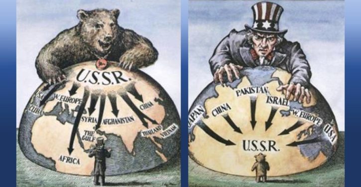
The Soviet Russian premise is better reflected in the final map below – one that we know reflects how the Soviets saw their situation, because Mikhail Gorbachev handed the original to George H.W. Bush at the superpower summit between the two of them off the island of Malta in December 1989.

I have reproduced the map found in the book by President Bush and Brent Scowcroft, A World Transformed (Alfred A. Knopf, 1998) on pp. 170 and 171. (The map from Gorbachev was prepared by hand.) Except as noted in the caption, all the information depicted on my version is the same.

The feel of the map is very different. Instead of looking splendidly central, the Russian Pivot Area looks sinisterly surrounded, with all the slings and arrows of the West pointing at it in a menacing manner.
It’s not that Western analysts failed to understand that Western alliances and military positioning placed limits, and were meant to, on the Rimland around the then-Soviet Heartland. That was the purpose of containment, after all. Depictions of Western containment precautions, like the one in this treatment by Gary E. Oldenburger, which shows the U.S. network of alliances, were common.

But in an important sense, the Soviet Union and the West spent the Cold War working on two different problems. The West was led by a United States that – according to the vision of Mackinder and Spykman – was outside the core of the World-Island dynamic, but because of that dynamic, needed to prevent the Soviet Heartland from gaining control of the World-Island.
Shoring up the Rimland was the basic strategy; i.e., containment. The extent to which we saw things in these terms, while America herself always had the sense of being on a periphery, cannot be overstated. The point is not whether we were right or wrong; it is that this is how we and the larger West perceived our common situation.
The Soviet Union, while its perspective could be largely described in Mackinder-Spykman terms, didn’t hold the Mackinder or Spykman axioms as its strategic premise. The importance of understanding that cannot be overstated.
The Soviet global strategy was political, ideological, and opportunistic; Russian geography was what we might call a separate but equal condition. To frame it in another illuminating way: a Soviet strategist would not have written a “geography of the peace” as a strategic guide to desirable or feasible end-states. Neither ideology nor the geographic perspective of Russia drove Soviet thinkers to do that.
The Reagan view
Interestingly, one American president was able to see the Soviets’ situation through their eyes, and perceived how effectively their Warsaw Pact empire was, in fact, surrounded. That was Ronald Reagan. What was geostrategic pessimism for Russian Communists was geostrategic optimism for Reagan, the American republican-democrat.
The Soviet Russians saw their essential maritime surroundedness from the 1920s on (see Kokoshin, pp. 78-79). But it was only in the 1980s, with the execution of the “Maritime Strategy” undertaken by Reagan (although its conceptual origins went back to Navy planners in the Ford presidency), that a U.S. president rammed that surroundedness home to the Soviet leadership, with intent.
It was the fruit of the Reagan strategy that Gorbachev’s map depicted when he handed it to Bush in December of 1989. (For verification of Reagan’s understanding of and involvement in implementing the Maritime Strategy of forward operation and forward defense, see numerous national security discussions in transcripts assembled by Jason Saltoun-Ebin in his two-volume The Reagan Files, self-published, copyright 2010 and 2012. Most of the relevant ones are in or before 1984. Peter Schweizer also deals with this in his book Victory: The Reagan Administration’s Secret Strategy That Hastened the Collapse of the Soviet Union; Atlantic Monthly Press, 1996.)
Reagan’s view was different from that of the West’s other Cold War thinkers, and from the Soviet view, because it was neither deterministic nor pessimistic. We’ll consider that point more in a later post in this series. For now, what is important in looking at the two geographies is that both of them were deterministic and pessimistic.
For the West, geography was destiny. It required taking precautions to outwit. For Soviet Russia, geography was a permanent disadvantage, especially for a revolutionary nation with a world-historical mission.
For Reagan, geography was a tool.
As with each of the pairings in this Centenary series, the point is not to settle arguments. Debate remains open. The point is the light they shed on our last century.
Earlier discussions of this and related geostrategic topics, which readers may find interesting, are at these links:
https://theoptimisticconservative.wordpress.com/2011/09/06/pax-americana-we-hardly-knew-ye/
https://theoptimisticconservative.wordpress.com/2009/07/24/two-wars-no-more-part-ii/
https://theoptimisticconservative.wordpress.com/2012/10/24/bayonets-horses-and-ships-oh-my/
* The first two posts:
The 1917 Centenary: Two visits
The 1917 Centenary: Two crucial maps